You can sponsor this page

Trisopterus esmarkii  (Nilsson, 1855)

Norway pout
Add your observation in Fish Watcher
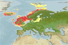
Native range | All suitable habitat | Point map | Year 2100
This map was computer-generated and has not yet been reviewed.
Trisopterus esmarkii   AquaMaps   Data sources: GBIF OBIS
Upload your photos and videos
Pictures | Google image
Image of Trisopterus esmarkii (Norway pout)
Trisopterus esmarkii
Picture by Dolgov, A.


Norway country information

Common names: Augnepål, Ogerpal, Ögerpål
Occurrence: native
Salinity: marine
Abundance: abundant (always seen in some numbers) | Ref: Cohen, D.M., T. Inada, T. Iwamoto and N. Scialabba, 1990
Importance: commercial | Ref:
Aquaculture: | Ref:
Regulations: | Ref:
Uses: no uses
Comments:
National Checklist:
Country Information: httpss://www.cia.gov/library/publications/resources/the-world-factbook/geos/no.html
National Fisheries Authority: https://odin.dep.no/fid/eng/
Occurrences: Occurrences Point map
Main Ref: Cohen, D.M., T. Inada, T. Iwamoto and N. Scialabba, 1990
National Database:

Classification / Names

Actinopterygii (ray-finned fishes) > Gadiformes (Cods) > Gadidae (Cods and haddocks)
Common names | Synonyms | Catalog of Fishes (gen., sp.) | ITIS | CoL

Main reference

Size / Weight / Age

Max length : 35.0 cm TL male/unsexed; (Ref. 1371); common length : 19.0 cm TL male/unsexed; (Ref. 4645); max. reported age: 5 years (Ref. 273)

Length at first maturity
Lm ?, range 11 - 15 cm

Environment

Marine; benthopelagic; oceanodromous (Ref. 51243); depth range 50 - 300 m (Ref. 54932), usually 100 - 200 m (Ref. 54932)

Climate / Range

Temperate, preferred 9°C (Ref. 107945); 79°N - 48°N, 27°W - 30°E (Ref. 54932)

Distribution

Northeast Atlantic: southwest Barents Sea, sometimes at Bear Island, south to the English Channel, - and the Bay of Biscaye (Ref. 90172)-, around Iceland and Faeroe Islands.
Countries | FAO areas | Ecosystems | Occurrences | Introductions

Short description

Dorsal spines (total): 0; Anal spines: 0. Gray-brown dorsally, silvery on sides, white on belly. A dark blotch is at the upper edge of the pectoral-fin base.

Biology     Glossary (e.g. epibenthic)

Benthopelagic to pelagic over muddy bottoms. Mostly found between 100 and 200 m. Feeds mostly on planktonic crustaceans (copepods, euphausiids, shrimps, amphipods) but also on small fish and various eggs and larvae (Ref. 1371). Caught mainly for reduction to fishmeal (Ref. 3383), trout pellets, fodder (Ref. 35388).

IUCN Red List Status (Ref. 115185)

Threat to humans

  Harmless


Human uses

Fisheries: highly commercial

More information

References
Aquaculture
Aquaculture profile
Strains
Genetics
Allele frequencies
Heritability
Diseases
Processing
Mass conversion
Collaborators
Pictures
Stamps, Coins
Sounds
Ciguatera
Speed
Swim. type
Gill area
Otoliths
Brains
Vision

Tools

Special reports

Download XML

Internet sources

Estimates of some properties based on models

Phylogenetic diversity index (Ref. 82805)
PD50 = 0.5625 many relatives (e.g. carps) 0.5 - 2.0 few relatives (e.g. lungfishes)

Trophic Level (Ref. 69278)
3.2   ±0.0 se; Based on diet studies.

Resilience (Ref. 69278)
Medium, minimum population doubling time 1.4 - 4.4 years (K=0.36; tm=2.3; tmax=5; Fec=27,000)

Vulnerability (Ref. 59153)
Low to moderate vulnerability (26 of 100)
Price category (Ref. 80766)
Low